Markets
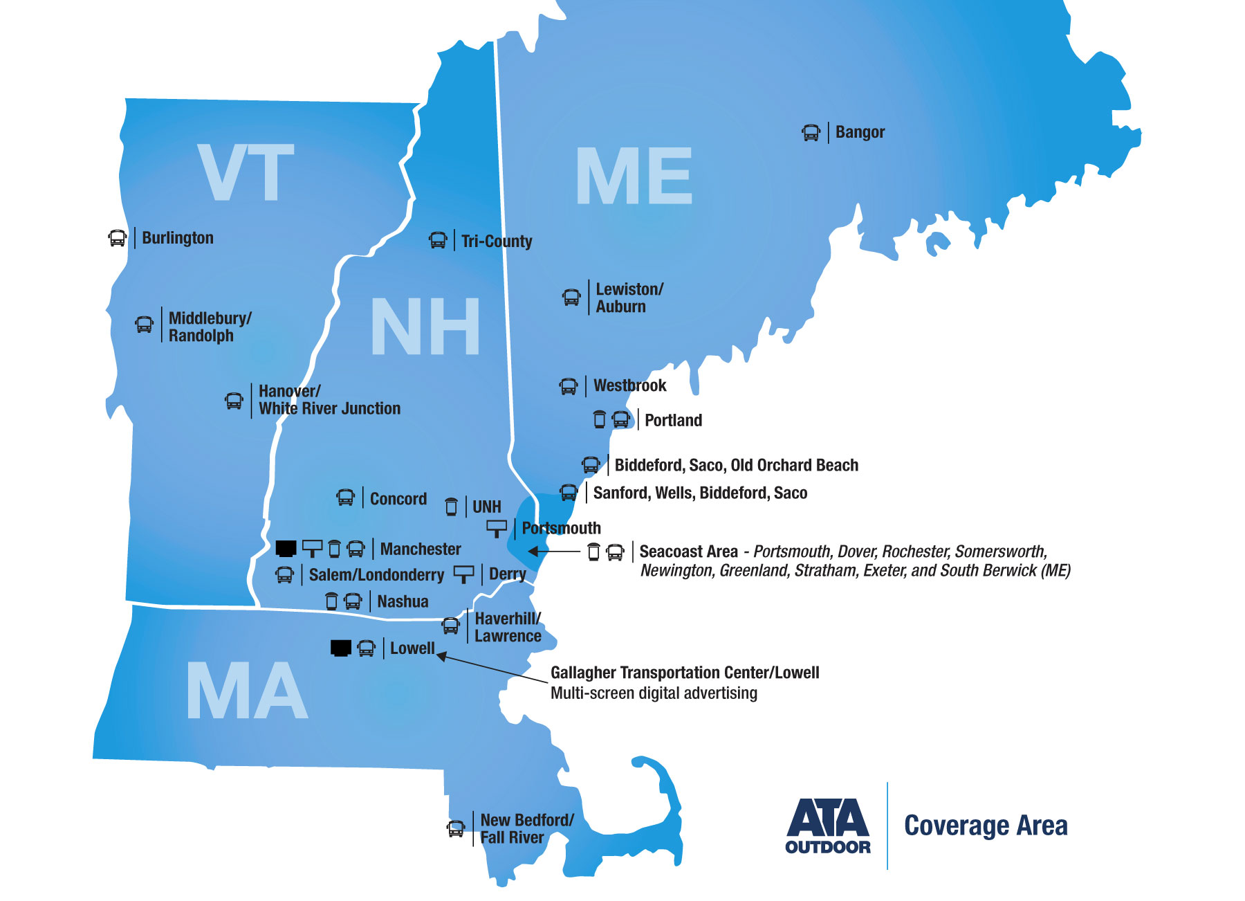
Market Details
Click the icons for more details
Transit Asset Card
Transit Route Map
Bus Shelter Map
Static Billboard
Digital Screen
Station Domination
MAINE
Bangor ![]()
![]()
Biddeford/Saco/OOB ![]()
![]()
Lewiston/Auburn ![]()
![]()
Portland ![]()
![]()
![]()
Sanford/Wells/Biddeford/Saco![]()
![]()
Westbrook![]()
![]()
MASSACHUSETTS
Haverhill/Lawrence ![]()
![]()
Lowell ![]()
![]()
![]()
New Bedford/Fall River ![]()
![]()
NEW HAMPSHIRE
Concord ![]()
![]()
Derry ![]()
Hanover ![]()
![]()
Manchester ![]()
![]()
![]()
![]()
![]()
Nashua, NH![]()
![]()
![]()
Northern NH/Tri-County![]()
![]()
Salem/Londonderry ![]()
![]()
Seacoast ![]()
![]()
![]()
![]()
UNH/Durham ![]()
VERMONT
Burlington ![]()
![]()
Middlebury/Randolph ![]()
![]()
White River Junction ![]()
![]()
Bus Shelters
| City | Number | Site At | Latitude | Longitude | Location |
|---|---|---|---|---|---|
| Manchester | NH001NB | Elm St. @ Gas St. | 42.977788 | -71.462920 | See Location |
| Manchester | NH003NB | Elm St. N/O Hanover St. | 42.990687 | -71.462915 | See Location |
| Manchester | NH004SB | Elm St. S/O Hanover St. (in front of City Hall) | 42.991141 | -71.463210 | See Location |
| Manchester | NH005NB | Elm St. @ Bridge St. | 42.993889 | -71.463002 | See Location |
| Manchester | NH007SB | Elm St. @ Granite St. | 42.986897 | -71.463206 | See Location |
| Manchester | NH008SB | Second St. & Woodbury St. | 42.974925 | -71.475614 | See Location |
| Manchester | NH009 | Woodbury St. & Dartmouth St. (off of Second St., behind strip mall) | 42.975361 | -71.477186 | See Location |
| Manchester | NH010NB | South Main St. @ Ferry St. | 42.982778 | -71.474217 | See Location |
| Manchester | NH011SB | South Main St. & Clinton St. | 42.982839 | -71.474398 | See Location |
| Manchester | NH017SB | River Rd. @ Park Ave. | 43.013576 | -71.468391 | See Location |
| Manchester | NH018SB | River Rd. @ W. Clarke St. | 43.009658 | -71.468028 | See Location |
| Manchester | NH021WB | Hanover St. @ Tarrytown Rd. | 42.989223 | -71.434738 | See Location |
| Manchester | NH034 | Elm St. in front of SNHU Arena (shelter closest to grass and Lake Ave.) | 42.986432 | -71.462928 | See Location |
| Manchester | NH035 | Elm St. in front of SNHU Arena (shelter closest to Harry Theo Ln.) | 42.986156 | -71.462924 | See Location |
| Manchester | NH036EB | Lake Ave. E/O Elm St. (side SNHU Arena) | 42.987124 | -71.462091 | See Location |
| Manchester | NH039SB | Elm St. @ Gas St. | 42.978184 | -71.463203 | See Location |
| Manchester | NH041SB | Elm St. & Wall St. | 42.993834 | -71.463260 | See Location |
| Manchester | NH043SB | So. Willow St. @ Goffs Falls Rd. | 42.949015 | -71.434186 | See Location |
| Manchester | NH044NB | So. Willow St. S/O So. Porter St. | 42.958679 | -71.436286 | See Location |
| Manchester | NH045NB | Elm St. @ Veteran’s Park | 42.988536 | -71.462924 | See Location |
| Manchester | NH046WB | Valley St. E/O Lincoln (IFO Manchester Shopping Center) | 42.983132 | -71.449311 | See Location |
| Manchester | NH047 | Agnes St. @ Pinard St. (Piscataquog River Apartments) | 42.99218 | -71.49681 | See Location |
| Manchester | NH048 | Keller St. (Carmax) | 42.950748 | -71.437846 | See Location |
| Manchester | NH049 | SB Elm St. Across from Veterans Park | 42.98814 | -71.46324 | See Location |
| City | Number | Site At | Latitude | Longitude | Location |
|---|---|---|---|---|---|
| Portland | 2 | 20 Bramhall St. @ Maine Medical Center opp. 31 Bramhall St. | 43.652255 | -70.274885 | See Location |
| Portland | 3 | 1360 Congress St. @ Westgate Plaza opp. Bradley St. | 43.659055 | -70.296557 | See Location |
| Westbrook | 4 | Mechanic St. @ Valley Square – Westbrook | 43.676405 | -70.368727 | See Location |
| Portland | 5 | Forest Ave. @ Hicks St. | 43.694904 | -70.303895 | See Location |
| Portland | 6 | Auburn St. S/O Rustic Lane | 43.709124 | -70.292229 | See Location |
| Portland | 7 | 1145 Brighton Ave. | 43.67607 | -70.32565 | See Location |
| Portland | 8 | 1124 Brighton Ave. | 43.675491 | -70.32563 | See Location |
| Portland | 9 | 320 Allen Ave. (Bangor Savings Bank) | 43.699062 | -70.289004 | See Location |
| Portland | 10 | 189 Park Ave. @ Iris Network | 43.658806 | -70.296149 | See Location |
| Portland | 11 | 46 Auburn St. | 43.703842 | -70.289608 | See Location |
| Portland | 12 | 370 Stevens Ave. @ Deering High | 43.670897 | -70.295117 | See Location |
| Portland | 14 | 196 Allen Ave. @ Casco Bay High School | 43.694633 | -70.292155 | See Location |
| Portland | 17 | Jetport Ave. | 43.642005 | -70.322914 | See Location |
| Portland | 19 | 580 Congress St. @ Forest Ave. @ Springers/Starbuck’s | 43.654417 | -70.262571 | See Location |
| Portland | 21 | 638 Congress St. @ Park St./IB @ LaFayette Hotel | 43.653317 | -70.26506 | See Location |
| Portland | 23 | 2 Monument Square – Congress St. @ Elm/Temple OB (outside Key Bank) | 43.657989 | -70.258278 | See Location |
| Portland | 25 | William Clark Blvd. @ Mechanic St. – Westbrook | 43.673456 | -70.369855 | See Location |
| Portland | 26 | 824 Stevens Ave. @ Shalom House across fm Bogusha’s Polish Deli | 43.686172 | -70.293621 | See Location |
| Portland | 28 | opp 34 Bedford St 1 | 43.662285 | -70.274526 | See Location |
| Portland | 29 | opp 34 Bedford St 2 | 43.662285 | -70.274526 | See Location |
| Portland | 30 | opp 34 Bedford St 3 | 43.662285 | -70.274526 | See Location |
| Westbrook | 31 | 134 Main St. & Liza Harmon Dr. (by Westport Bowling Lanes) – Westbrook | 43.678014 | -70.335889 | See Location |
| Portland | 32 | 1345 Washington Ave. & Northport Dr.(by Cumberland County Federal Credit Union) | 43.698698 | -70.287088 | See Location |
| Freeport | 33 | 525 US Rt 1 opp. Maine Beer Co. (in front of Park + Ride) – Freeport | 43.839526 | -70.121769 | See Location |
| Westbrook | 34 | 300 Spring St. & Blue Spruce Farm Rd. – Westbrook | 43.660462 | -70.36164 | See Location |
| Westbrook | 35 | 320 Spring St. & Landing Rd. – Westbrook | 43.625032 | -70.347586 | See Location |
| Portland | 36 | 605 Stevens Ave. | 43.679132 | -70.294481 | See Location |
| Portland | 38 | Poland St. @ Stevens Ave. (at UNE campus) | 43.684495 | -70.293755 | See Location |
| Westbrook | 39 | 58 Main St. (Rock Row) – Westbrook | 43.67765 | -70.33282 | See Location |
| Gorham | 41 | 95 Main St. | 43.68081 | -70.4393 | See Location |
| Portland | 42 | 900 Congress St @ Maine Medical Ctr | 43.653889 | -70.2775 | See Location |
| City | Number | Site At | Latitude | Longitude | Location |
|---|---|---|---|---|---|
| Dover, NH | 1 | Knox Marsh Rd./Trestle Way | 43.18133 | -70.89276 | See Location |
| Rochester, NH | 2 | 31 Wakefield St. @ Crocker St. (in front of City Hall) | 43.30536 | -70.97604 | See Location |
| Rochester, NH | 3 | 150 Wakefield St. (in front of Community Center) | 43.31621 | -70.97735 | See Location |
| Somersworth, NH | 4 | 311 NH-108 (Goodwin Community Health) | 43.25801 | -70.90197 | See Location |
| Somersworth, NH | 5 | 450 High St. (Goodwill) | 43.23119 | -70.88214 | See Location |
| Farmington, NH | 6 | 527 Main St. | 43.39075 | -71.06509 | See Location |
| Farmington, NH | 8 | Route 153 Main St. opposite Pleasant St. | 43.38881 | -71.06440 | See Location |
| Farmington, NH | 9 | Tappan St. & Rt. 11 (Rite-Aid) | 43.38509 | -71.07487 | See Location |
| Rochester, NH | 11 | 129 South Main St. (By BP Gas) | 43.29978 | -70.97101 | See Location |
| Dover, NH | 12 | 46 Chestnut St. (Dover Police Department) | 43.19580 | -70.87679 | See Location |
| Dover, NH | 13 | 611 Central Ave. (Tasker) | 43.20372 | -70.87531 | See Location |
| Dover, NH | 14 | 622 Central Ave. (U-Haul) | 43.20394 | -70.87567 | See Location |
| Somersworth, NH | 16 | 41 High St. (VFW/City Hall) | 43.26283 | -70.86475 | See Location |
| Dover, NH | 17 | Whittier St. (Dover Housing Authority) | 43.20321 | -70.89645 | See Location |
| Dover, NH | 18 | Whittier St./Tolend Rd. | 43.20011 | -70.89543 | See Location |
| Dover, NH | 19 | Whittier St./Pleasant View Circle | 43.20015 | -70.89521 | See Location |
| Portsmouth, NH | 20 | Gosling Rd. (Gosling Meadows) | 43.09302 | -70.79661 | See Location |
| Portsmouth, NH | 21 | Lafayette Rd. (Lens Doctor) | 43.05433 | -70.76993 | See Location |
| Portsmouth, NH | 22 | 215 Commerce Way (C3 Metrics) | 43.08987 | -70.78429 | See Location |
| Portsmouth, NH | 23 | Commerce Way (Marshalls Plaza) | 43.09009 | -70.78922 | See Location |
| Portsmouth, NH | 24 | 2319 Lafayette Rd. (Taco Bell) | 43.03413 | -70.78138 | See Location |
| Portsmouth, NH | 25 | Constitution Ave. (Veridian Apartments) . | 43.03425 | -70.78486 | See Location |
| Portsmouth, NH | 26 | 26 Lafayette Rd. (Crossroads) | 43.05615 | -70.77011 | See Location |
| Dover, NH | 27 | Rt 108 (@ Strafford Farms) | 43.22804 | -70.8954 | See Location |
| Dover, NH | 28 | Knox Marsh Rd./Rt. 155 | 43.179722 | -70.896944 | See Location |
| Rochester, NH | 29 | Market Basket Blvd, The Ridge Rte 11 Rochester, NH | 43.332559 | -71.008907 | See Location |
| Rochester, NH | 30 | Market Basket Blvd, The Ridge Rte 11 Rochester, NH | 43.332699 | -71.009198 | See Location |
| City | Number | Site At | Latitude | Longitude | Location |
|---|---|---|---|---|---|
| Durham, NH | 001 | Main St. @ Pettee Brook Lane | 43.135327 | -70.928968 | See Location |
| Durham, NH | 002 | Main St. @ Hetzel Hall | 43.134496 | -70.927098 | See Location |
| Durham, NH | 005 | Main St. @ Thompson Hall #1 | 43.136988 | -70.932594 | See Location |
| Durham, NH | 007 | Main St. @ Thompson Hall #3 | 43.136988 | -70.932594 | See Location |
| Durham, NH | 008 | Main St. @ Holloway Commons | 43.135265 | -70.928994 | See Location |
| Durham, NH | 009 | Main St. @ The Whittemore Center | 43.138308 | -70.93481 | See Location |
| Durham, NH | 010 | Main St. @ The Field House | 43.139617 | -70.938067 | See Location |
| Durham, NH | 014 | McDaniel Dr. @ 33 Academic Way (Kingsbury Hall) | 43.133595 | -70.935155 | See Location |
| Durham, NH | 015 | 15 Academmic Way @ 5 Quad Way (McConnell Hall/Hitchcock Hall) | 43.132729 | -70.931464 | See Location |
| City | Number | Site At | Other Name | Latitude | Longitude | Location |
|---|---|---|---|---|---|---|
| Nashua, NH | 1 | 127 West Hollis Street – Nashua NH | 12th & Hollis | 42.75200101 | -71.48309673 | See Location |
| Nashua, NH | 2 | 166 Kinsley Rd (St Josephs Medial Office) – Nashua NH | St Josephs Hospital | 42.75054912 | -71.47924411 | See Location |
| Nashua, NH | 3 | 69 Amherst Street – Nashua NH | Holman Stadium | 42.76805486 | -71.47507248 | See Location |
| Nashua, NH | 4 | 5 Independence Drive – Nashua NH | Independence Drive | 42.72696115 | -71.44518141 | See Location |
| Nashua, NH | 5 | 420 Amherst Street – Nashua NH | 420 Amherst St | 42.78759328 | -71.514059 | See Location |
| Nashua, NH | 6 | 509Amherst Street – Nashua NH | Nashua Community College | 42.79407455 | -71.52470502 | See Location |
| Nashua, NH | 7 | 103 Spit Brook Road – Nashua NH | 103 Spit Brook Rd | 42.70775343 | -71.4540737 | See Location |
| Nashua, NH | 8 | 51 Canal Street – Nashua NH | BAE/Canal St | 42.76417028 | -71.45904847 | See Location |